Friday, April 6, 2007

Dirty Fighing Emptying Ocean


In June, along the shoreline of Mauritania, in northwest Africa, scientists made a gruesome discovery: the carcasses of 230 dolphins, a pilot whale, and 15 endangered hawksbill and leatherback sea turtles.
"Because of the mixture of species found, and the fact that some of them were entangled in sections of fishing nets, it is likely that these animals were killed as bycatch," said Jean-Christophe Vie, deputy coordinator of the World Conservation Union's species program, based in Gland, Switzerland.

Across the world's oceans, large commercial fishing boats haul aboard huge nets and 60-mile (97-kilometer) lines teeming with unwanted creatures—bycatch, sometimes referred to as "bykill" or "dirty fishing."
Bycatch is a mix of young or low-value fishes, seabirds, marine mammals, and sea turtles, often considered worthless and tossed overboard—dead or dying.
Collateral Damage
The collateral damage amounts to about 30 million tons (about 27 million tonnes) of sea life each year, says marine ecologist Jane Lubchenco of Oregon State University—about one-third the total global catch. Among the worst offenders are shrimp trawlers, who often discard up to 10 pounds of sea life for each pound of shrimp they catch.
"If a hunter is hunting for elk, he's not killing sparrows, eagles, coyotes, and pronghorn," said Elliott Norse, president of Marine Conservation Biology Institute (MCBI) in Redmond, Washington. "That's different in the sea. We fish blindly—and it's an exceedingly wasteful way of doing things."
A recent barrage of scientific reports detail alarming declines in many fish and other marine animal populations. One of these, published in the journal Nature, states that just 10 percent of swordfish, sharks and other large, predatory fish remain in the world's oceans after just 50 years of commercial fishing.
Without immediate action, they could go the way of the dinosaurs, warns study author Ransom Myers, a fisheries biologist from Dalhousie University in Hallifax, Nova Scotia.
High-Impact Fishing
Bottom trawling inflicts the most damage on the undersea environment, according to an MCBI report funded by the Pew Charitable Trusts titled "Shifting Gears." Trawlers drag weighted nets up to a quarter-mile wide along the ocean floor, bulldozing deep-sea coral reefs and other seafloor ecosystems where many sea animals live or breed. It is the equivalent of clear cutting forests to hunt deer, said Norse.
The study also classified gill nets and longline fishing as "high impact". With these methods, "you're catching and killing everything that swims by," says Daniel Pauly, a marine biologist at the University of British Columbia. (all info from Nationalgeographic.com)

Sable Island


Sable Island is a small Canadian island situated 180 km (111mi) southeast of Nova Scotia in the Atlantic Ocean. As of 2001, the island is home to around 15 people. Sable Island is specifically mentioned in the Constitution of Canada as being the special responsibility of the federal government, but for many political purposes it is part of District 13 of the Halifax Regional Municipality.

Sable Island is a narrow crescent-shaped sandbar with a surface area of about 3400 ha. Despite being nearly 42 km or 26 mi long, it is no more than 2 km or 1.25 mi across at its widest point. It emerges from vast shoals and shallows on the continental shelf which, in tandem with the area's frequent fog and sudden strong storms including hurricanes and northeasters, have caused over 300 recorded shipwrecks. It is often referred to as the Graveyard of the Atlantic, as it sits astride the great circle route from North America's east coast to Europe. The nearest landfall is 160 km to the northwest near Canso, Nova Scotia.
Sable Island was named after its sand—'sable' is French for 'sand'. It is covered with grass and other low-growing vegetation. Sable Island is believed to have formed from large quantities of sand and gravel deposited on the continental shelf near the end of the last ice age. The island is continually changing its shape with the effects of strong winds and violent ocean storms. The island has two freshwater ponds on the south side between the station and west light. There are frequent heavy fogs in the area due to the contrasting effects of the cold Labrador Current and the warm Gulf Stream. During winter months, the moderating influence of the Gulf Stream can sometimes give Sable Island the warmest temperatures in Canada.
Sable Island should not be confused with Cape Sable Island in southwestern Nova Scotia.

The island is home to over 250 free-roaming feral horses which are protected by law from human interference. The best evidence for the origin of the horse population is that they are descended from horses confiscated from Acadians during the Great Expulsion and left on the island by Boston merchant Thomas Hancock, uncle of John Hancock.
In the past, excess horses have been rounded up and shipped off the island for use in coal mines on Cape Breton Island, or to be sold, but the Government gave full protection to the horse population in 1960, and they have been left alone ever since.
Several large bird colonies are also resident; Arctic terns, and Ipswich sparrows (Passerculus sandwichensis princeps), a subspecies of the Savannah Sparrow that breed in no other location. Harbour and Grey seals also breed on the island's shores. There is also a species of freshwater sponge (Heteromeyenia macouni) found only in ponds on the island. (all info from Wikimedia Inc.)

Exxon Valdez


Exxon Valdez was the original name of an oil tanker owned by the former Exxon Corporation. It gained widespread infamy after the March 24, 1989 oil spill in which the tanker hit Prince William Sound's Bligh Reef and spilled an estimated 11 to 30 million U.S. gallons (50,000 m³ to 150,000 m³) of crude oil: the Exxon Valdez oil spill, or the EVOS. As a result of the spill thousands of animals perished in the following months. The best estimates are: 250,000 sea birds, 2,800 sea otters, 300 harbor seals, 250 bald eagles, up to 22 orcas, and billions of salmon and herring eggs. In addition, the oil killed off a majority of the plankton supply in the sound. Many centers were set up to clean animals but they were too late in many cases. The captain of the Exxon Valdez, Joseph Hazelwood, was then found guilty of negligence — he admitted he had been drinking vodka before boarding the vessel — and in 1991 a federal judge approved a $1.1 billion settlement reached by Exxon, the federal government, and Alaska.
The vessel had an all steel construction, built by National Steel and Shipbuilding Company in San Diego. A relatively new tanker at the time of the spill, it was delivered to Exxon in December 1986. The tanker was 300 m long, 50 m wide, and 27 m in depth (987 ft by 166 ft by 88 ft), weighing 30,000 tons empty and powered by a 31,650 shp (23.60 MW) diesel engine. The ship could transport a maximum of 1.48 million barrels (200,000 t) at a sustained speed of 16.25 knots (30 km/h) and was employed to transport crude oil from the Alyeska consortium's pipeline terminal in Valdez, Alaska, to the lower 48 states of the United States. The vessel was carrying about 1.26 million barrels, or about 53 million gallons, when it struck the reef. The accident would have been contained, but the captain only reported it as a minor accident.
After the spill, the Exxon Valdez was towed to San Diego, arriving on July 10 and repairs began in July 30, 1989. Approximately 1,600 tons of steel were removed and replaced. In June 1989 the tanker left harbor after $30 million of repairs.
Exxon operated the tanker in Europe to avoid further publicity, renaming it the Exxon Mediterranean, and later the Sea River Mediterranean (under the Exxon subsidiary SeaRiver Maritime). The Sea River Mediterranean remains in service, with its name further shortened to S/R Mediterranean, then to simply Mediterranean under the Marshall Island flag but is prohibited by law from entering Prince William Sound. The vessel may face scrapping in the near future, due to a global ban on single-hulled tankers, despite the ship being only about halfway through its operational life expectancy. (all info from Wikimedia Inc.)

Coral Reefs


Coral reefs are aragonite structures produced by living organisms, found in shallow, tropical marine waters with little to no nutrients in the water. High nutrient levels such as that found in runoff from agricultural areas can harm the reef by encouraging the growth of Algae. In most reefs, the predominant organisms are stony corals, colonial cnidarians that secrete an exoskeleton of calcium carbonate (limestone). The accumulation of skeletal material, broken and piled up by wave action and bioeroders, produces a massive calcareous formation that supports the living corals and a great variety of other animal and plant life. Although corals are found both in temperate and tropical waters, reefs are formed only in a zone extending at most from 30°N to 30°S of the equator; the reef-forming corals do not grow at depths of over 30 m (100 ft) or where the water temperature falls below 22 °C (72 °F).


Coral reefs can take a variety of forms, defined in following;
Apron reef — short reef resembling a fringing reef, but more sloped; extending out and downward from a point or peninsular shore.
Fringing reef — reef that is directly attached to a shore or borders it with an intervening shallow channel or lagoon.
Barrier reef — reef separated from a mainland or island shore by a deep lagoon; see great Barrier Reef.
Patch reef — an isolated, often circular reef, usually within a lagoon or embayment.
Ribbon reef — long, narrow, somewhat winding reef, usually associated with an atoll lagoon.
Table reef — isolated reef, approaching an atoll type, but without a lagoon.
Atoll reef — a more or less circular or continuous barrier reef surrounding a lagoon without a central island; see atoll.
Bank Reef — Bank reefs are larger than patch reefs and are linear or semi-circular in outline.

(All info from Wikimedia Inc.)

Wednesday, March 21, 2007

Grand Banks


The Grand Banks are an important aspect of Atlantic Canadian culture due to their economic impacts and the lesson learned by the overfishing of this area and the subsequent depletion of one of the largest fish stocks in the world. I took a Canadian history course at Mount Royal College in Calgary and we discussed the implication of the overfishing of the Grand Banks in detail and after this I understood how awful it was and how bad it looked on the Canadian government that we were not able to control this problem. The Grand Banks are a group of underwater plateaus southeast of Newfoundland on the North American continental shelf. These areas are relatively shallow, ranging from 25 to 100 metres in depth. The cold Labrador Current mixes with the warm waters of the Gulf Stream here.The mixing of these waters and the shape of the ocean bottom lifts nutrients to the surface. These conditions created one of the richest fishing grounds in the world. Fish species include Atlantic cod, haddock and capelin. Shellfish include scallop and lobster. The area also supports large colonies of sea birds such as Northern Gannets, shearwaters and sea ducks and various sea mammals such as seals, dolphins and whales.
In addition to the effects on nutrients, the mixing of the cold and warm currents often causes fog in the area. Canada is currently performing the hydrographic and geological surveys necessary for claiming the entire continental shelf off eastern Canada, under the auspices of the latest United Nations Convention on the Law of the Sea. Once this aspect of UNCLOS is ratified, Canada will presumably control these remaining parts of Grand Banks which are outside of its EEZ jurisdiction.
Petroleum reserves have also been discovered and a number of oil fields are under development in this region, most notably the Hibernia, Terra Nova, and White Rose projects; the harsh environment on the Grand Banks also led to the Ocean Ranger disaster.

Portuguese Mon O' War


Since we were discussing these creatures today in class, I decided I would make a blog on the Portuguese Mon O' War. I remember when I was younger my parents went on a cruise and when they came back they told me that there was a swing on the boat that you could swing off of to jump into the water, and an unfortunate individual jumped onto a Man O' War and was in rough shape. It is also interesting that a creature that is not a predator can be so harmful to humans.


The Portuguese Man O' War (Physalia physalis), also known as the blue bubble or bluebottle, is commonly thought of as a jellyfish but is actually a siphonophore—a colony of four sorts of polyps.The Man O' War's float is bilaterally symmetrical with the tentacles at one end, while the chondrophores are radially symmetrical with the sail at an angle. Also the Man O' War has a siphon, while the chondrophores do not. The Portuguese Man O' War has an air bladder; known also as a pneumatophore or sail, that allows it to float on the surface of the ocean. It has no means of propulsion and is pushed by the winds and the current. The sail is filled with air, but may build up a high concentration of carbon dioxide (up to 90%). The bladder must stay wet to ensure survival; every so often it may roll slightly to wet the surface of the float. To escape a surface attack, the pneumatophore can be deflated allowing the Man O' War to briefly submerge.


The sting from the tentacles is potentially dangerous to most humans; these stings have been responsible for several deaths, but usually only cause excruciating pain. Detached tentacles and specimens washed up on shore can sting just as painfully as the full creature in the water, for weeks after detachment. The venom can travel up to the lymph nodes and may cause, depending on the amount of venom, more intense pain. In extreme cases medical attention is necessary.
According to a study done by Dr. Geoffrey Isbister of Newcastle, Australia's Mater Hospital in 2003 through 2005, the best treatment for a sting is to apply hot water to the affected area. Hot water used in the study was fixed at 45 degrees Celsius (113 Fahrenheit). The hot water eases the pain of a sting by denaturing the toxins.
Applying ice to the area of the sting is also a fairly effective way to suppress the pain. Ice works by making the toxins less active and reduces the sensation and therefore pain of the area of skin around the ice. Additionally, ice constricts blood vessels, reducing the speed at which the poison travels to other parts of the body, including the brain; heat has an opposite effect. It was originally thought that applying ice was the best way of dealing with Man O' War stings before the study was done. Lifesavers around the world still use ice to treat the stings of this species.

(All information for this blog entry is from Wikipedia)

Saturday, March 3, 2007

Zeolites of the Bay of Fundy


Zeolites are an important industrial mineral that are found in only a few areas around the world. They have very unusual chemical properties. The two main areas worldwide known for their rich zeolite abundances are in the Bay of Fundy and in the Poona Field in India. Zeolites are found in amygdaloids and veins in the North Mountain volcanic basalt formation. They are normally found in between zones of successive lava flows. The zeolites were deposited after the crystalization of the basalt and have a hydrothermal origin. The north mountain dates to the Jurassic Era, making it around 190 million years old. The north mountain is composed of many tilted layers dipping toward the Bay of Fundy, and the zeolites are normally found along the top layers of the lava flows. The basalt is exposed along the south side of the Bay of Fundy, especially near Parrsboro, and various local islands.


Zeolites have an interesting chemistry composed of hydrated aluminosilicates with alumina and silica linked with oxygen atoms. They also contain some calcium and/or sodium. Zeolites are framework silicates that are related to the feldspar family. However, they form under lower pressure and in more temperate environments. Zeolites contain ports, or open lattice structures in the zeolite molecules that make passageways. For example, in a half pound of zeolite, there is enough surface area from the pores to cover an entire football field. The pore diameter and characteristics are homogeneous. There are several types of zeolites found along the Bay of Fundy. These are:


1. Analcite which has a hardness of 5.5 and are found on Two Islands, Amethyst Cove, Cap d'Or, and Swan Creek.


2. Apophyllite which has a hardness of 4.5-5.0 and is found on Amethyst Cove, Sheffield Bluff, Isle haute, Port George, and Murray Brook. Apophylltes are not actually zeolites, but are closely related.


3. Chabazite which has a hardness of 4.5 and is found in Wassons Bluff, Partridge Island, and Moose Island.


4. Gmelinite which has a hardness of 4.5 and are found on Two Islands, Pinnacle Island, Wassons Bluff, and Partridge Island.


5. Heulandite which has a hardness of 3.4-4.0 and are found in Harbourville, Bennett Bay, Sheffield Bluff, and Wassons Bluff.


6. Mesolite which has a hardness of 4-5 and are found in Port George, Margaretsville, Halls Harbour, Amethyst Cove, and Cap d'Or.


These are just a few of the many zeolites that are found along the North Mountain.

(all information for this entry was taken by a handout from Dr. G. Pe-Piper in the department of Geology, as well as from Wikipedia).

Saturday, February 24, 2007

Hibernia Oil Field


In my petroleum geology class, we have been discussing the Hibernia Oil field and its contribution to the world's petroleum production. The Hibernia oil field is Canada's largest offshore oil operation and is located 315km SE offshore of St. John's, Newfoundland. The platform itself is the world's largest physical offshore oil platform and is made of 37,000 tons of integrated topsides that is all mounted on a 600,000 t gravity base structure (which means that the platform itself sits on the ocean floor due to the very shallow depth on the Grand Banks and has very large tanks filled with magnetite ballast that weigh 1.2 million tons, securing the rig in place). There is enough storage on the platform to hold 1.3 million bbl of crude oil. We learned in class that the Hibernia platform produces enough oil in one year to supply the entire world for one day. In other words, it produces 0.00274% of the worlds oil supply. If you want to put the world's petroleum usage into physical parameters, each day the entire world uses enough oil to fill a tank that is the size of the whole SMU campus and that is 100m high. It is amazing to think that we have been consuming this amount of oil on a constant day to day basis.
Exploration drilling of the Hibernia oil field began in the 1960s and lasted for a few decades before, in the mid-1980s, Mulroney said that the main commercialization of Hibernia was going to be done by Petro-Canada. At the time, Petro-Canada was a crown-corporation but has since been privatized. It took several years to get the production up and running, and only with the help of a few competitor oil companies assistance (which were Mobil; now ExxonMobil, Chevron, Murphy, to name a few) was the field able to begin major production. The production began on November 17, 1997 and has proven to be very successful ever since. There is a fleet of tankers that travel continuously back and forth between the platform and the Avalon Peninsula transporting the crude oil. I find this oil field interesting because of its close proximity to Halifax, and how much crude oil it actually produces. It has been good for the economy of Newfoundland as well with the depletion of the fish in the Grand Banks.

Monday, February 12, 2007

Mariana Trench


I think that the Mariana Trench is the most interesting feature in any ocean. I have also wondered about this part of the ocean (before I was in university) because I knew only that it was the deepest part of the ocean, and that we knew next to nothing about the landscape of life that resides in the trench. I remember my grade 12 global geography teacher was trying to make a point about how little relief is actually on the planet, and he drew a large quarter of a circle across three chalk boards to represent the earth, and then drew in a little peak about an inch high representing Everest and a trench about the same size and said it was Mariana Trench. I also remember him saying that if you cut off Mount Everest and put it inside the Trench that it would fit in and still have a few kilometers until the ocean surface. I think that is what made me interested in the Trench. It is 11,034 meters below sea level and is located south of Japan and east of the Philippines, close to Guam. The Trench is part of a subduction zone where the Pacific plate is being subducted under the Philippine plate. It was first surveyed by the Royal Navy vessel Challenger in 1951. The scientists used echo sounding techniques to estimate its depth at 11,022m. It was later estimated that its depth was 10,911 meters, but most recently (as of February 6, 2007), the trench was measured at 11,034, making the initial estimate at its depth more accurate than subsequent guesses.

In 1960, a dive was attempted in the United States Navy Bathyscape named "Trieste" with the hopes of reaching the bottom of the trench. U.S. Navy Lieutenant Don Walsh and Jaques Piccard were on board, and at 1:06pm on January 23, the bathyscape hit the bottom. The pressure was measured at 1,086 bar, or 15,751 psi, which is approximately 1000 atmospheres greater than at the surface. There have been other estimates at its depth and pressure by other countries, but all estimates seem to be within 50 meters of each other. Marianas Trench has also been a part of popular culture as it is referred to in several movies including Deep Rising, The Core (where the team of scientists try to reach the centre of the Earth and start their journey by entering the asthenosphere through Mariana Trench) to name a few. It has also been mentioned in several novels and songs.

I also find it very interesting how little we know about the trench. It has been stated in the Oceans course that we know less about the oceans than we do about Mars, and seeing as Mariana Trench is the deepest part of any ocean, to me it is like another planet except we know that there IS life there and we still have much to learn. I think about how little we know about the Trench at this point in my life, and I wonder how much we will know when I am 40, 60, or 80 years old (knock on wood). The problem that I see with these discoveries is that with so many other issues to focus on, exploring the deep sea is not on the top of the global scientific priority list (when compared to issues such as global warming, solving world hunger, etc.) and therefore it may be several decades to centuries before these discoveries are made.

(for this writeup, I used Wikipedia as well as marianatrench.com)

Sunday, February 4, 2007

Seafloor Spreading


Sea floor spreading is one part of the theory of plate tectonics. I find this process interesting because it is responsible for creating our oceans and also is one of the ways that our Earth reproduces rock material in the lithosphere. I often think about the many interconnected processes that have helped to shape our world to what it is today. Seafloor spreading also allows us to predict what or planet will look like in many years to come, as well as allowing us to predict natural hazards.


The theory of seafloor spreading was hypothesized in 1960 by Harry Hess who was a professor at Princeton University. Though Alfred Wegener originally thought of the idea of continental drift, Harry Hess was able to find proof of the spreading mid-Atlantic ridge during World War II. Hess was captain of the USS Cape Johnson which was a trans-Atlantic transport ship that was equipped with Sonar, which at the time was a relatively new technology. Though the sonar was used to find hidden submarines, Hess was able to collect data from the seafloor and upon analyzing the information, noticed that there was a magnetic anomaly that showed identical patterns on either side of the middle of the ocean (mid-Atlantic ridge). He hypothesized that the Ocean was spreading, and used these magnetic anomalies as proof. On either side of the ridge, the seafloor's magnetic orientation changed over time, and produced an obvious pattern (each side of the ridge had identical magnetic properties). This phenomenon was caused by the magnetic north pole changing over time from our geographic north and south poles, and hence the orientation of the isotopes in the rock are altered. He produced his results in a paper titles "History of Ocean Basins" which was released in 1962. For a long while after, this paper was the single most referenced work in solid-earth geophysics (Wikipedia).


I believe that in science, the huge leaps and discoveries are taken by researchers who are willing study topics different from the normal idea and way of thinking to go out on a limb and try and prove a theory that, at the time, may see impossible. At the time, Hess was not as well received by some of the scientific community, but over time, his theories have been monumental in geology. The same goes for Alfred Wegener; after releasing his paper on Continental Drift, it was not well received, and he had many critics. For one, Wegener was not even a geologist; he was a meteorologist which made it difficult for leading geologist to trust his theory. I think that these men and women are greatly responsible for the great leaps we have taken in science. This reminds me of a quote from my favorite movie, A Beautiful Mind starring Russell Crowe, when he said "Find a truly original idea. It is the only way I will ever distinguish myself. It is the only way I will ever matter." It seems that the scientists that are not only trying to build on what other scientists have discovered in the past, but come up with truly original ideas, are the ones that will be remembered long after they pass away.

Monday, January 29, 2007

Ophiolites


Ophiolites are one of my favorite types of rocks because they are very interesting to study and are extremely important in reconstructing past tectonic settings. An ophiolite is a stratified slab of oceanic crust that has been uplifted onto land and is then exposed with continental rocks. The word ophiolite comes from the Greek words "ophio" meaning snake, and "lite" meaning rock. Ophiolites are found in a distinct stratigraphic sequence which corresponds with its formation underwater. This sequence is as follows:


1. Sediments, usually black shale or chert

2. An extrusive sequence consisting of pillow basalts that were solidified by the ocean water. This also shows the magma-sea water contact

3. Sheeted dikes, which are vertical and parallel, which is also the origin of the pillow basalts

4. High level intrusive rock, usually isotropic gabbro which shows evidence of a fractured magma chamber

5. Layered Gabbro

6. Cumulative Peridotite which usually forms in dunite-rich mineral layers

7. Tectonized Peridotite which will normally be Harzburgite/Iherzolite-rich mantle rocks


These rocks are also very important in geological dating. By assessing the location of the ophiolites today, as well as analyzing the fossils/mircofossils found in the ophiolite, a timeline sequence can be created and in some cases, a good estimate of the ophiolite's original location can be described. These rocks were mentioned several times in a few different geology courses I have taken because the are applicable to many different areas of study. Ophiolites are also an important factor in interpretation geophysics. Since we have only explored the first 25% of the oceanic crust, these rocks can can prove very useful when comparing them to surroundings of in situ oceanic crust. Ophiolites have been found in various areas around the world such as:


-Joruma Ophiolites in Finland

-Troodos Ophiolites in Cyprus

-Vourinos and Pindos Ophiolites in Greece

-Semail Ophiolites in Oman and the United Arab Emirates

-Various types in various locations throughout Newfoundland

-Yakuno Ophiolites in Japan


Ophiolites can be divided into two groups: Tethyan and Cordilleran, based on their location. Tethyan ophiolites are found in the Eastern Medeterranian region while Cordilleran Ophiolites are normally found in the North American region. Though the two groups follow similar sequences, they are have individual characteristics specific to their region. Hopefully in the future, geologists can use these rocks to open more doors in the field of submarine geology and oceanic crust processes.

Friday, January 26, 2007

Cameron, Louisiana


When you think of hurricanes and Louisiana, the first one that comes to mind for most people is Katrina and its impact in New Orleans. However, the southern states were also hit by another monster storm, Hurricane Rita, only a month after Katrina. I found it interesting how the media viewed each hurricane depending on how it affected the public. Katrina was one of the most deadly and costly hurricanes in American history, however the storm was not as intense as Rita. Hurricane Katrina was formed on August 23, 2005 and made its way into the Gulf of Mexico before hitting land south of New Orleans. It had recorded wind speeds of 280 km/h. However, the most alarming fact is the 81.2 billion US$ in damages. It dissipated on August 31, 2005. However, I learned more about Rita during the summer, and was able to see the damages almost a year after the event. Rita was formed on September17, 2005 and made its way through the Gulf of Mexico along a similar course as Katrina, except Rita hit land a few hundred kilometers to the west of Katrina's path. It only killed 120 people (7 directly) and had 11.3 billion US$ in damages (in comparison to Katrina), however it affected people on the other side of the state in a similar fashion to Katrina in New Orleans. In my previous article, I had mentioned the town of Cameron, a port town on the Gulf coast of Louisiana. After I arrived in Louisiana and did a week of safety training courses, I made my way to Cameron to move into the boat and install the equipment and hardware we were going to use for our survey. The drive to the town is one that I will never, ever forget for the rest of my life. I was driving an SUV and was by myself for the two and half hour trek. When I was about 45 minutes from Cameron, I started driving south towards the coast. Louisiana is very flat due to its location relative to the Mississippi River. Over millions of years, the topography has been flattened due to the ever-fluctuating meander pattern of the river. While I drove south, I remember that the pavement for the road was elevated about 5 or 6 feet and there was water and swamp all around, though it was not very thick and I could see for a few kilometers in any direction. The road was relatively straight, and I remember I came to a huge opening and throughout the fields I could see houses scattered randomly. When Rita hit, there was a huge storm surge resulting in an 18 foot flood that had picked up the houses and moved them several kilometers. I remember that I had a very upsetting feeling and it was then that I actually realized what the storm must have been like. Before going to Cameron, I was told by some of my coworkers that it was one of the most devastated towns and that it was very intense. I did not have a camera for my drive, but like I said, it is a mental image that I will never forget. As I approached the town, it was like I was watching a movie. The town of Cameron is about the size of downtown Bridgewater ( 2000-3000 people) and after Rita hit, there were only a few buildings left standing. The town hall/library building was damaged, but held together. There was also a store, and the house of one of the richest men in the town. He had his house built on stilts 15 feet off the ground in case of a hurricane. Every other building in the town was demolished, some of them were actually the houses I had seen in the fields on my drive. The next day, I walked around the town by myself and took pictures of what I saw. As I began my work on the boat, some of the workers on the boat that were not part of our survey crew (there were two crews, the surveyors and the boat crew who were locals) had told me about the storm and how it had changed their lives. The town had been rebuilt, but it was all FEMA trailers. The thing I found most interesting was when I walked around the town, there were tons of properties that consisted of a concrete foundation with nothing on top, and a trailer set up beside the foundation, and a flagpole on almost every front lawn with an American flag. I thought about the fact that even though they had lost practicly everything, they still had some hope and some national pride. I know that this article is not exactly about the physical geography of the ocean, but I feel that it is definatly related since the Gulf of Mexico is a part of the lives of all the Cameron residents, and living in a close proximity to the ocean and hurricane territory was a risk that all the locals were willing to take. Also, I find it amazing that the water can rise up to 18 feet above normal sea level and stay like that for weeks on end. I have added some pictures from the day that I walked around. In a nutshell, the entire town looked like the houses in the pictures and this was 10 months after the storm.

Sunday, January 21, 2007

Side Scan Sonar Fish


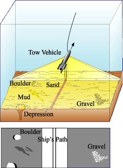
In this blog I am going to talk about Side Scan Sonar Technology and its application in my summer job. I knew nothing about sonar fish and related survey equipment. On the boat, we were running two "projects", a multibeam survey and a side scan sonar survey, though the two went hand in hand. There are a few different types of SSS fish, though the one that used primarily was the Klein 5000. It is rather large and heavy, and looks similar to a torpedo. The fish is towed behind the boat usually around 15m behind the stern. It has two receivers on either side about 3 feet long. The devise works by sending out hundreds-thousands of pings per second (a ping is a beam that is sent from the fish) and then calculating the return travel time (the amount of time it takes for the ping to leave the fish, bounce off the ocean floor, and return to the fish). By using this technique, it is possible to calculate the distance travelled by each individual ping, which results in a very detailed map, or bathymetry, of the ocean floor. There are many other factors involved in this process. For one, the velocity of each ping is greatly effected by the physical properties of the ocean water. The water is very diverse and can change greatly within only a few kilometers. To compensate for this issue, another devise called a seabird, is cast off the side of the boat. The seabird consists of two cylindrical shaped tubes that are held together by a metal frame. To use this devise, the boat has to come to a complete stop, and the seabird is manually lowered at a rate of 1m/second. Since the water is very shallow, it does not take very long until the seabird hits the ocean floor. While the seabird is lowered, it records the water pressure, temperature, salinity, current, etc with respect to water depth. This data is then uploaded to the ships computers where several graphs are made, as well as an algorithm that is applied to all of the data. This compensates for any unusual readings recorded by the SSS fish. The software accompanying the fish is capable of recording all of the pings and resulting bathymetry to result in a map of the ocean floor. The SSS operator has to be very careful when operating the equipment because if the water depth change, the fish could hit the bottom and possibly detach from the cable and be left on the bottom. Also, the range of the fish is proportional to its height from the floor (since the angle that the pings are sent is the same at any depth, and high fish altitude will result in a broader range). However, there is a small altitude range at which the fish can be and still receive a clear image. I have added an image of the fish I found from the web that gives a visual reference of how the fish works. Also, there is a picture of the fish on our boat and the A-frame that allows the workers to drop the fish off the back of the boat.

Wednesday, January 17, 2007

Summer Story... pt. 1


While in class today, I thought of an idea for my blogs. This summer, I was hired as a junior geologist for a company called Highland Geo Solutions, which is based out of Fredericton. Though I had anticipated on working in Fredericton for the summer doing sedimentary work on various local rivers, a week into the job my boss informed me that he had landed a contract with a company in Louisiana and that my collegue and I were going to be working in the south for the remainder of the summer. At the time, I was unsure of what was going to happen or what type of work we were going to be doing. It turned out that the company I was working for was called C & C Survey Technologies, a rather large Geophysical and Marine Survey company based out of Lafayette, La. There are several divisions in the company. I was working in the NOAA division. A few months before I arrived in Louisiana, C & C and NOAA (National Oceanographic and Atmospheric Administration) signed a contract for a continental shelf survey project of which I worked on all summer. The contract was worth upwards of 100 million dollars, and as the summer progressed, I became more aware of how important the work we were doing actually was to many groups of people. Basically, we had several mapped blocks of water that were within 500m-20km away from continental United States and Mexico, and we were performing both a Side Scan Sonar survey, as well as a multibeam survey. The port of Fourchon, which is located almost directly south of New Orleans on the Gulf Coast, is one of the largest and most trafficked ports in the Gulf. Directly south of Fourchon is one of the most congested areas of the gulf with the extremely high frequency of traffic as well as hundreds to thousands of oil rigs and satellite gas platforms (I remember one morning I went on the top deck and counted 110 platforms/rigs that I could see within view of our boat). When Hurricane Katrina ran its course towards New Orleans, many of these platforms and rigs were damaged. Since the petroleum companies were aware of the impending storm, all of the platforms and rigs were turned off and evacuated, however many of them were damaged and there was debris that had sunk to the bottom and was proving to be hazard to boats going in and out of Fourchon. As well, the water within a few km was very shallow (usually between 20-35m), so if there were pipes or other material on the ocean floor, it was very possible for the boats to be struck. Anyway, my idea for my blog was to divide the many different parts of my summer, as well as what I learned while living on the boat, and write several blogs detailing several individual topics. I think that it will be a good way for me to write down my memories from the summer, as well as allow readers to gain an understanding of what life is like on a boat, and how different technologies are advancing in the field of oceanography and marine survey. As well, I think it is important for people to understand how greatly the people of Louisiana, Texas, Mississippi, Alabama, etc, were affected by the storm. The one thing I learned this summer that I find the most valuable is how ineffective CNN is at depicting events such as the Katrina disaster, Hurricane Rita, etc. Perhaps it isn't that CNN is no effective, but that we as a society as so used to watching television that it almost as if we watch the events occur on the screen, but since we are not there to experience them, it does not really hit home. I was able to meet many people that lost their home, every belonging that they had to their name, and were only left with their wives and children and the hope that one day things would be alright. (The picture at the top is in Cameron, a port town just south of Lake Charles and about a 45 min drive from the Texas/Louisiana border)

Monday, January 8, 2007

First Blog...

Well this is my rookie blog. During our first lecture in the class, we talked about the history of Oceans. Some of the material was interesting. I found the part regarding the melting glaciers particularly interesting. It also made me think about how mild of a winter we have had so far, and that there are noticeable changes in climate in the last short period (my lifetime). There are so many theories postulated regarding the change in climate and its affect on mean sea level. It is hard to comprehend the severity of this problem, and in turn, the steps that will be required to compensate for such issues. The part I find particularly intriguing is the interconnectedness of the many subsystems that that are under the influence of the rising sea level. For example, a change in sea level can effect local and regional climates, marine and maritime wildlife, transportation which can effect economy, etc. The most troubling fact is that we are unable to predict how our world will change. The only steps we are able to take to prevent such problems are to reduce our greenhouse gas emmissions and to conduct further research in this study area to try and hypothesize what may occur.