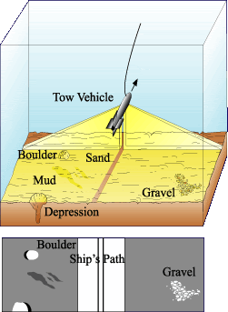

In this blog I am going to talk about Side Scan Sonar Technology and its application in my summer job. I knew nothing about sonar fish and related survey equipment. On the boat, we were running two "projects", a multibeam survey and a side scan sonar survey, though the two went hand in hand. There are a few different types of SSS fish, though the one that used primarily was the Klein 5000. It is rather large and heavy, and looks similar to a torpedo. The fish is towed behind the boat usually around 15m behind the stern. It has two receivers on either side about 3 feet long. The devise works by sending out hundreds-thousands of pings per second (a ping is a beam that is sent from the fish) and then calculating the return travel time (the amount of time it takes for the ping to leave the fish, bounce off the ocean floor, and return to the fish). By using this technique, it is possible to calculate the distance travelled by each individual ping, which results in a very detailed map, or bathymetry, of the ocean floor. There are many other factors involved in this process. For one, the velocity of each ping is greatly effected by the physical properties of the ocean water. The water is very diverse and can change greatly within only a few kilometers. To compensate for this issue, another devise called a seabird, is cast off the side of the boat. The seabird consists of two cylindrical shaped tubes that are held together by a metal frame. To use this devise, the boat has to come to a complete stop, and the seabird is manually lowered at a rate of 1m/second. Since the water is very shallow, it does not take very long until the seabird hits the ocean floor. While the seabird is lowered, it records the water pressure, temperature, salinity, current, etc with respect to water depth. This data is then uploaded to the ships computers where several graphs are made, as well as an algorithm that is applied to all of the data. This compensates for any unusual readings recorded by the SSS fish. The software accompanying the fish is capable of recording all of the pings and resulting bathymetry to result in a map of the ocean floor. The SSS operator has to be very careful when operating the equipment because if the water depth change, the fish could hit the bottom and possibly detach from the cable and be left on the bottom. Also, the range of the fish is proportional to its height from the floor (since the angle that the pings are sent is the same at any depth, and high fish altitude will result in a broader range). However, there is a small altitude range at which the fish can be and still receive a clear image. I have added an image of the fish I found from the web that gives a visual reference of how the fish works. Also, there is a picture of the fish on our boat and the A-frame that allows the workers to drop the fish off the back of the boat.
1 comment:
That's a great post, Craig. I will mention it to the class tomorrow (assuming you don't mind). I was going to briefly mention sonar.
Cathy
Post a Comment